PART I: The WOW Hiking Event
The Marvelous Hiking Trail: Old Wuta Hiking Trail in Nan-ao
幾天前,Robert在Forumosa.com談到於本週週四,他將探勘南澳地區的仲岳溪登山步道的路況;同時,他也提到歡迎有興趣的山友參與。這週以來,氣候狀況非常良好,即使連經常霧濛濛台北天空,都是一片藍天白雲。我不想放過在這樣美好天氣裡,到自然環境探索的機會,在調整值班時間後以便報名參加。這次的登山活動是在非假日,大多數的山友無法參與,所以當天只有我和Robert能夠成行。
Few days ago, Robert posted on Forumosa.com that he would go to explore Zhong-yue Stream (仲岳溪) hiking trail in Nan-ao (南澳), and hikers who would like to join in the hike were welcome. I had great interest in the hike and felt like to come along. The weather has been really nice for days in Taipei. The sky of Taipei city has been brightly blue dotted with some white clouds. The grayish sky that Taipei city used to have was gone. I didn’t want to miss this chance to explore unknown natural region in such a fine day, and I want to enjoy warm sunny day outdoor; so I readjusted my working schedule and took part in the hike. Thursday is regular work day for most people, so Chris and Kitty couldn’t make the trip. It turned out that only Robert and I could go hiking in Nan-ao.
我們八點時,在木柵集合。在木柵地區上高速公路前,因為是上班時間,車流量大,我們的行車速度不如預期,但是在上高速公路後,路況良好,我們很快地抵達宜蘭頭城。繼續往蘇花公路行進,後轉南方澳,再抵達南澳。由於Robert是第二次到這個地區,所以我們這次的車程,比之他和Katannya的南澳溯溪行順利很多(詳情請參考部落格Pashan),這樣的路程大約花費我們二個小時的時間(不過,出門在外,迷路總是難免,詳情請參考本文第二部)。我們很順利的沿著產業道路找到登山口,沿途的風景十分美好,而且路面狀況良好,我們一致地認為這段自行車旅行的天堂。
Our rendezvous time was 8:00 in Mu-zha (木柵)。We were slow down because of the heavy traffic during rush hours. But after we hit the highway to Yi-lan (宜蘭), there was almost no traffic, and we arrived at Tou-cheng (頭城) approximately in one hour. We took Road No. 9 (台九線:蘇花公路段) and headed to Nan-fan-ao (南方澳) and then got to Nan-ao. This trip was Robert’s second or third time to visit Nan-ao, so the drive to Nao-ao was smooth, and it was much better than the drive Katannya and he had in their trip to Nan-ao river-tracing few weeks before. (Please refer to the blog: Pashan for further details) We only spent about two hours getting to the country road leading to the trailhead of Zhong-yue Stream hiking trail. The scenery along the country road was very nice, and the road’s surface was well-maintained, we both thought the road was perfect for cycling. Soon we got to the trailhead without encountering any obstacle.
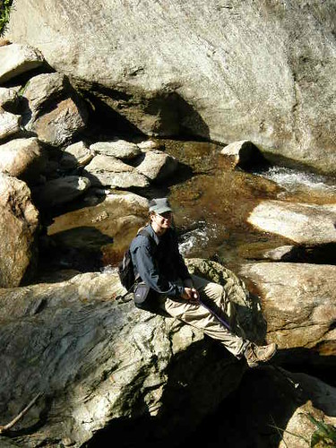
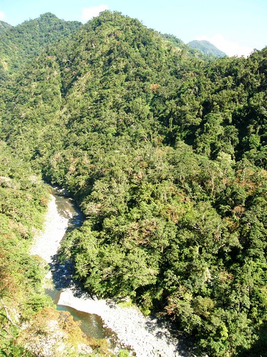
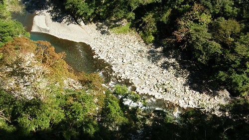
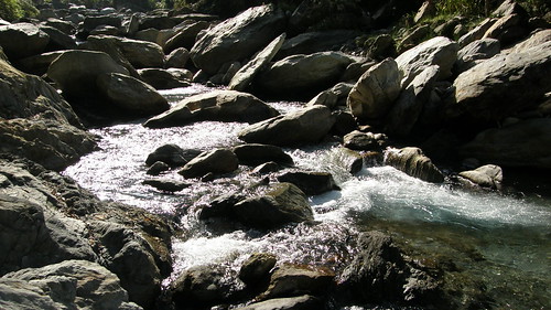
在抵達仲岳溪登山口後,由於前方尚有小徑,Robert基於好奇心,便繼續直行,看察前方的路況。我們車行至產業道路底,前方出現二條小徑,其一是通達河床的小路,我們先前往河床看查,這條河應該是南澳南溪。看到眼前的美景,我們兩個人神速地拿出相機,啪嚓啪嚓地按下快門,希望能把眼前這片美景帶回家。
After we arrived at the trailhead of Zhong-yue Stream hiking trail, Robert found the country road seemed to continuously lead to other places. Out of his curiosity, he decided to move forward to see what kind of surrounding at the end of the road would be. As we got to the end of the road, two branch trails appeared. One of them was a short path leading to a riverbank (Note 1) . We took the trail to the riverbank to check the surroundings out. As we saw the beautiful scenes unfolding in front us, we spontaneously took our cameras to take pictures of this great spot.

註解:Robert很專注地拍攝河邊風景,因為Robert穿深色的衣服,他的影像實在是不太清楚。
Caption: Robert was concentrating on taking pictures of beautiful scenery of the riverbank. However his image doesn’t stand out in my picture because he wore dark-blue clothes.
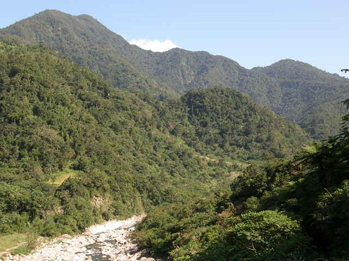
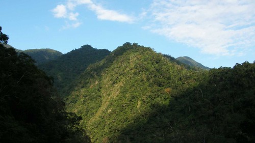
註解:從河邊眺望遠山
Caption: Looking at the distant mountains from the riverbank.
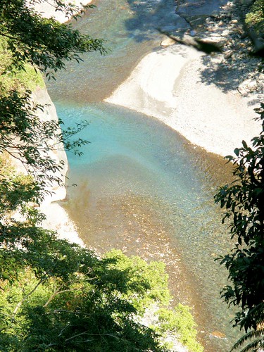
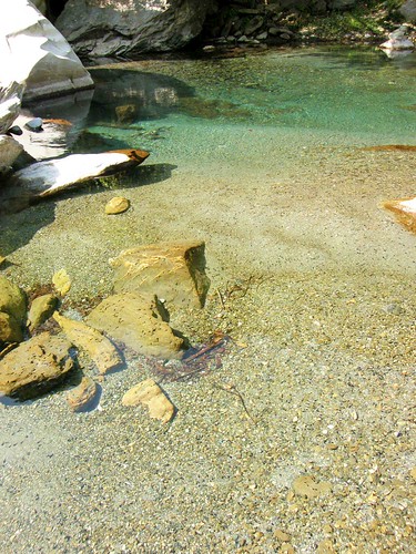
註解:河水清澈,我的相機可以輕易地拍攝水中小蝌蚪的影像。先前在三峽滿月園時,我也看到成群的蝌蚪,興沖沖地拍了很多照片,但在回家後才發現,但是受到水質混濁的影響,照片裡的小蝌蚪都糊掉了。Caption: The stream was very clean. I could take images of those tadpoles in the stream easily with my not state-of-the-art camera (Note2).
另一條小徑,則是舊武塔古道。
Another trail at the end of road was Old Wuta hiking trail.
這條古道是舊時泰雅族人的取鹽之道,在清代和日據時代,則被作為用征討與警備泰雅族人的道路。山裡的武塔村等其他泰雅族部落,由於住民陸續地遷出,現在只剩下過去的部落遺跡。
In the past, Atayal people traveled to coastal regions in order to fetch salt. It was important for Atayal people to contact with other regions. However, the Ching government and Japanese colonial government took the advantage of the trail respectively to intrude Atayal villages. (Note1)
另一條小徑,則是舊武塔古道。Another trail at the end of road was Old Wuta (舊武塔) hiking trail.
這條古道是舊時泰雅族人的取鹽之道,在清代和日據時代,則被作為用征討與警備泰雅族人的道路。山裡的武塔村等其他泰雅族部落,由於住民陸續地遷出,現在只剩下過去的部落遺跡。
In the past, Atayal people traveled to coastal regions in order to fetch salt. It was important for Atayal people to contact with other regions. However, the Ching government and Japanese colonial government took the advantage of the trail respectively to intrude Atayal villages.(Note3)
 註解:舊武塔古道介紹說明板 Caption: The introduction board of the Old Wuta hiking trail
Robert在看完登山口的介紹後,當下決定捨棄仲岳溪步道,改為探勘舊武塔古道。Robert read the introduction board and changed his mind immediately. He decided to explore the Old Wuta hiking trail instead of Zhong-yue Stream hiking trail.
我們取道舊武塔登山步道,Robert穩健地大步向前,可是我不像Robert那樣自信滿滿地。我不知道前方的路況,對未知的恐懼和興奮湧進胸口。我像一隻小老鼠般地畏畏縮縮地摸索向前,深怕一角踩進陷阱;但又蹦蹦跳跳地,覺得前方有好吃的起司,尾隨在Robert之後。
We took the Old Wuta hiking trail. Robert confidently moved forward in big strides; however, I didn’t have confidence as he did because I didn’t know what would be waiting for me on the road and I dislike things out of my control. Fear and excitement came to me simultaneously. I felt like I was a timid little mouse tagging along behind Robert, flinching from stepping into traps, but reluctantly moving forward because of my anticipation of the beautiful scenery along the trail.
步道的狀況良好,林相優美;而且黃葉繽紛,隨風飄搖落地,面對這樣的景色,我是驚嘆不絕。往左看,我只能說,這真的是太美了!再往右看,我只能說,這真的是太棒了!
As we hiked on the Old Wuta hiking trail, I found that the trail’s condition was pretty good. The trail was not as challenging as I was afraid of. The forest was graceful and had multiple facets. I could see lush forest in different tones of green, and I could see rains of yellow and orange leaves swinging and falling down on the ground.
The path was full of wonders!
"This is amazing!" I exclaimed with excitement as I looked at the trail's left side.
"That is wonderful!" I shouted as I looked at the trail's right side..
And I repeatedly said: "This is paradise!"
I think I was very noisy and talkative that day. I thought reason must be that I had too much coffee and was caffeine overdosed.
But the region is ABOSLUTELY like a paradise. That's the really reason why I was so excited.
註解:古道狀況良好。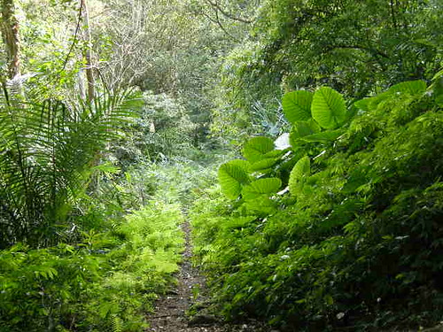 註解:古道的青蔥翠綠林相。
 註解:古道落葉繽紛(抱歉,我的相機太差,無法捕捉到落葉的影像。)
行進不久,我們抵達支流的河床。在支流之上,山崖之間,有座頹敗失修的木橋,我心想不知這座木橋,是否就是是過去泰雅族人與清漢人與日人之間通聯的遺跡。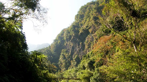
註解:木橋在照片下方(抱歉,這張拍的不夠好。)
註解:老大哥裝可愛,我不打算把這個註解翻成英文,不然會被K的。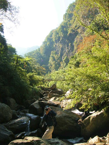

在涉過支流後,我們繼續前行。其實我心底對於前方的路況完全沒有概念。只能小心翼翼地往前行進。但是沿途美景是最佳的誘因,我亦步亦趨地前,心懷期待地等著另一個美景的出現。
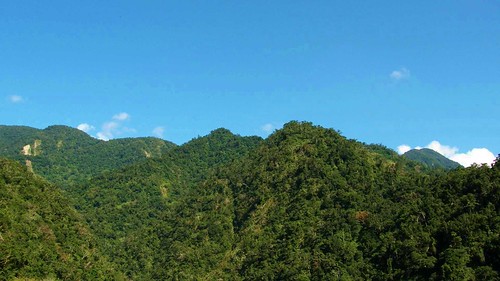
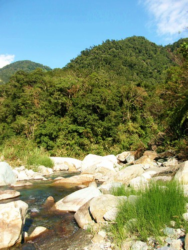
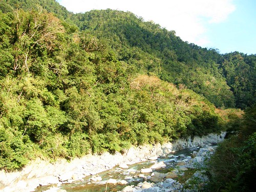
我後來發現,舊武塔古道的路況很像加九寮步道,路況其實很好,雖然有幾處坍方,需要很小心地攀爬,但它的展望比加九寮步道好,有很好的視野眺望遠方山巒,細察蜿蜒河谷。
註解:由遠至近看南澳南溪

這裡是我們享用午餐的好地方。
由於我們還有第二個行程:朝陽國家步道,所以回程時,以較快的速度返回登山口。途中遇到美景,我們稍作暫停,將美景銘刻腦海,然後繼續前行。我們大約花費1個小時又45分的時間,便抵達登山口。
 註解:在重返登山口後,日光已經稀微,但是天空還是一樣的湛藍迷人。
Robert想知道關於舊武塔古道的細節,所以要我問這位先生一些問題。這位先生的中文雖然帶有一些腔調,但是我可以很清楚地理解他所陳述的內容。(記得有一次在阿里山上遇到一位可愛的原住民小姐,她不會說中文,只是用「感恩」來回應我。)他所陳述的大概內容是古道串連的泰雅村落:舊武塔、舊金洋,到四季等。以他們習慣山路的人的腳程來說,要花兩天的時間才能往返舊武塔村,像我們這種肉腳,要花的時間會更多。古道沿途,早無村落,現在所留下的只剩當時村莊的斷垣殘壁。但是,他們泰雅族人常會循著古道,回到過去祖先居住的村落,祭拜祖靈。
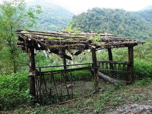
往朝陽步道的路上,我們看見一座頹敗的木屋。這座木屋很有趣的是在於它的是由筆筒樹所支撐。我們興致勃勃地停車拍照。這時,又有人聲問道:「你們要去哪裡啊?」三位騎乘摩托車的泰雅族原住民好奇地問著我們。大概又是擔心我們是迷途的人。我們在說明後,問他們是否知道是誰構築這座木屋。他們說這是護溪的人隨便搭造的,臨時做來晚上過夜遮蔽用的,現在已經無人使用。天色漸漸昏暗,我也好奇地問他們要去哪裡?他們告訴我他們正要前往山上的薑田工作,工作是噴灑農藥。我在用英文向Robert解釋他們即將進行的工作後,Robert跟我說他和Richard和原住民互動後的經驗,而我只能默默無語。
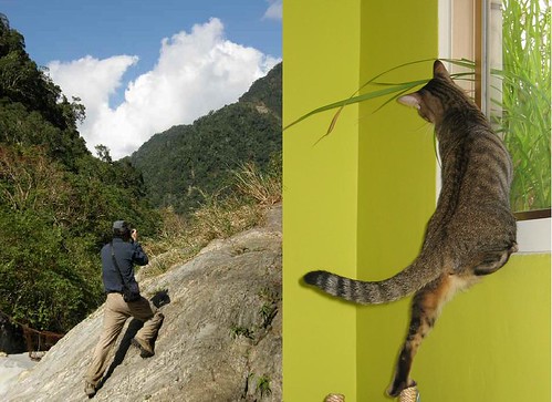 備註:右邊的貓是Robert的寵物貓Ping,聽說這隻貓很活潑可愛,Robert有一次把貓咪的照片放在flicrk上,被我下載下來。這次,我拍到Robert這張照片,跟Ping很像。果然,主人和寵物之間,是有類似的行為模式。
In 1889, LIU Chao-dai (劉朝帶), LIU Ming-chuan's nephew, led a team about 500 soldiers developed a path in mountainous region at Xiao Pi-nan-tang (小埤南塘) in Xiao Nan-ao, they tried to find a route to reach San-pu-li village (前山埔里社). In search of San-pu-li village, LIU Chao-dai and his men were attacked by Atayal people of Lao-gou-fan village (Lao-gou-fan, 老狗番, literally means old dog barbarian) at Dong-si-ren-keng (Dong-si-ren-keng, 凍死人坑, literally means freeze to death in Chinese). Approximately 300 soldiers were killed in this encounter which included LIU Chao-dai himself.
LIU Ming-chuan was furious as he learned the news and decided to punished the Atayal people from Lao-gou-fan village.
In 1890, LIU, Ming-chuan turned to the Navy of Fu-jian province for naval support. He acquired armed forces, weaponry, salary, and food supply. His troops stationed in Su-ao(蘇澳)
在安全返家後,因為超喜歡這段登山步道,所以我特別上網蒐集一些關於舊武塔古道的資訊。舊武塔古道是比亞毫古道的東段,在林務局的國家步道系統中,有相關的介紹和簡圖說明。
國家步道系統 (中文) http://www1.forest.gov.tw/nt/TR_F_02.aspx
National Trail System (English) http://www1.forest.gov.tw/NationalTrailSystem_En/TR_F_02.htm
I wrote this additional information in English and I don’t translate them into Chinese because this additional information is written in Chinese.
Lanyang Museum News Letters(蘭陽電子報) http://ilmuse.gov.tw/~epaper/form/pastnews.htm
Among the news letters, a issue titled with 2008年2月第37期電子報(南澳鄉巴博凱凱社) is articles about a investigation of the Atayal village--b' bukeykay in Nanao.
A very simplied translation into English by me.
The author led a team to go to Nanao mountain region and the route they took is below:
Day one:
1. 舊武塔古道 (Old Wuta trail, I learned from the article that this trail is the Eastern part of 比亞豪 Biyahao古道old trail, Biyahao trail starts from 金洋村 Jinyang Village to 四季 Sici, this trail is planed to be renovated by Forestry Bureau.)
2. 合流溪(Heliu Stream) to 新楠子駐在所(New Nanzi police station, set up by Japanese)
3. Atayal Gugus village via Japanese police patrol path
4. 布蕭丸溪 (Buxiaowan Stream) to Taipower hut in 砲台山 (Paotai Shan)
5. Camped at Taipower hut because of a member's muscle cramp.
Day Two:
1. 布蕭丸溪 (Buxiaowan Stream) to 舊楠子駐在所(Old Nanzi police station, set up by Japanese)
2. 和平北溪 (Hepin Northern Stream)
3. Atayal haburns' lus village, set up a camp site.
Day Three:
1. 和平西北溪 (Hepin Northwestern Stream)
2. 各姆河 (Gemu River)
3. Atayal b'bukeykay village
After their investigation at Atayal b'bukeykay village, they took same route back to Wuta village.
Note: They had to do river tracing whenever they encountered rivers or streams.
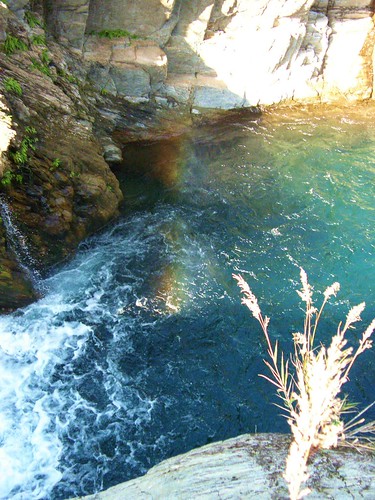
Here is the site of this river tracing group, two teams from the site took trip along Old Wuta trail and got to a hot spring fountain called Mohe Hot Spring Fountain(莫很噴泉). The site provides with few interesting videos of the hot spring fountain
http://dar999.pixnet.net/blog/post/14386004And this team's pictures give their readers great understanding of the route's condition.
http://dar999.pixnet.net/album/set/13515671
This team took similar route that taken by the abovementioned research team.
According to the aritlce from the river-tracing site, there are great hot spring and hot spring fountain in Buxiaowan Stream (布蕭丸溪) and Mohen Stream (莫很溪).
PART II: Finding Nemo
我們在順利的探訪舊武塔古道後,繼續往朝陽國家步道前進。Robert拿一本地圖給我,交代我要把路線看清楚。我很快的找到朝陽國家步道的位置,步道的登山口似乎離南澳市區不遠。我估計著,心想以這樣的距離,大概是要花30分鐘吧!所以,我們還是有機會攀登依山傍的朝陽步道。我問Robert以這樣的距離,大概要花多久的時間?他說只要10分鐘就可以到。我是大感吃驚,從地圖上看來,登山口離我們很遠,後來,我才知道,我忘記參考地圖的比例尺(又學了一課,看圖要搞清楚比例關係。)
雖然不會看地圖,但是我還是很高興,因為我覺得可能有機會看到夕陽。然後Robert又說:那裡面東,沒辦法看夕陽。啊!我馬上又出槌。可是,我突然有新的領悟。如果是看日出的話,那麼步道應該念作朝(ㄓㄠ)陽步道,而不是朝(ㄔㄠˊ)陽步道。Robert不知道這兩種發音的不同,我心想:哈!哈!我贏了吧!(這句當然也不會翻成英文,不然鐵定被K。),我當然是很有耐心地用我的破英文解釋這破音字之間的不同。
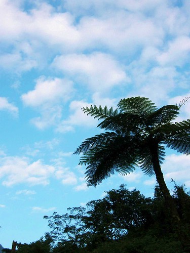
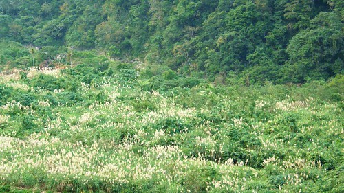 備註:往朝陽國家步道的路上,看見連綿不絕的芒草花。
我們穿過市區的7-11後,往海邊的方向前進。我心想,可以看到海的步道,一定可以是在海邊附近。所以,我們車行便朝著海邊,一路直行。可是,莫名其妙地,鄉間小路前慢慢浮現山巒。地圖上的指標,都沒有出現在我們行進的路上,說不一定,小路是繞過山巒的,繞過山巒後,海景就會在眼前出現。所以Robert一路直行,最後,到最後—死路一條。
我們下車,看看四周的景象,試著尋找可能的方向。一隻小狗拼命的在後方狂吠,左邊是荒田和公墓,右邊是野地和破敗的鐵皮屋。在眼前的水泥橋上,我看一個「朝」字,我高興地告訴Robert,那一定是往朝陽國家步道的方向!可是,我發現,我們正在一條田間小路上,前方已無路可行。我們得要繞回先前我們錯過個岔路,往另一個方向走,才能上橋。Robert試著要倒車,要我在旁編指示方向和距離。我們花了一些時間,想辦法要把車子掉頭。但是,這路實在是太窄,他放棄把車子掉頭,並決定要倒行回到岔路口。當然,原本計畫抵達朝陽步道的10分鍾,早就過去了。
在當時,我覺得這樣的狀況實在是很好玩。一個人在一輩子裡,會有多少機會可以遇到這樣的蠢事(亦順遇到這樣的事情的機會可能比較大)。我還很高興地說:我要拍照,我要把這樣好笑的事情拍下來做紀念,想當然爾,老大哥是不理我。所以沒有照片,但是我畫一張圖以資紀念。

最後,我們很安全地回到岔路口,謝謝Robert,很小心的以安全為優先。
我們從岔路出發,轉往朝陽路,直接抵達朝陽漁港,天已經黑了,但沿路上,我們都沒有看到登山口的指示。最後我們決定放棄,要回台北。車子往回行走時,我們突然看到登山口的標示,我們很高興地要一探究竟,這時候,天開始下雨(突然覺得這趟旅行,可以媲美亦順的李歐納柯恩Leonard Cohen演唱會之行)。
4 comments:
Great report, Kate. Can I use some of your history translation for my blog?
Patty told me today that the Luodond Forestry department is in the midst of restoring the trail all. They've spent NT30 million. They still need to put a few suspension bridges in. Can't wait to hike the whole thing.
Btw, did you take your new blog cover pic? Where is it from?
Sorry, should be Luodong.
No problem, but however, I haven't translated all background information in hands. I need more days to translate it.
I read a project of Yilan government online a while ago.
The government's project is to restore Biyahao Historic Trail, abd Old Wuta trail is the estern section of it. I think it would take hikers 4-5 days to finish hiking the whole Biyahao trail.
I think this is as same as what Patty has told you.
You can refer to http://www1.forest.gov.tw/NationalTrailSystem_En/TR_F_02.htm for details and map of the trail. It's in English.
By the way, the cover pic is my picture taken during my hiking in Cixing Shan. I love it! :)
Post a Comment